Project Overview
BACKGROUND
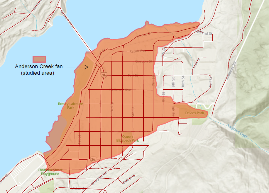
The Fairview neighbourhood sits on the Anderson Creek fan (see Definitions to the right and map below). About 1,600 homes and nearly 2,000 people live here. The area also includes shops, community spaces, and Nelson’s main east–west transportation corridor (Highway 3A). Anderson Creek and Fell Creek carry rain and snowmelt from steep mountains through Fairview and into Kootenay Lake.
Floods and debris floods (see Definitions to the right) from Anderson Creek are not new. These natural events have shaped the area for thousands of years and have happened on and off since the neighbourhood was built. Records from the past 130 years show several events, often during spring snowmelt or heavy rain on snow.
In 2022–2023, the City reviewed local creeks to find where more detailed study was needed (view the report here). Anderson / Fell Creek was identified as a priority due to:
- the density of residential development in Fairview;
- the concentration of transportation routes and infrastructure; and
- the potential consequences of overland flooding in this area.
Earlier studies showed there is flood risk, but they did not fully explain how water and debris behave within the fan area during strong rain or storm events (how far, how fast, how deep), how risk changes across the neighbourhood, or what actions would reduce risk best. To fill these gaps, the City received funding through the UBCM Disaster Risk Reduction–Climate Adaptation program and hired BGC Engineering to complete a detailed hazard and risk study.
WHY IS THE CITY DOING THIS STUDY
Anderson Creek is a steep creek (see Definitions to the right) that runs through the Fairview neighbourhood and is one of the City’s drinking water sources, along with 5 Mile and Selous Creeks. Because the creek carries rain and snowmelt and flows near homes and roads, it’s important to understand how it may behave during heavy rainfall. As the climate changes, more frequent and intense rainfall events are anticipated.
This study provides the City of Nelson with a comprehensive, science-based understanding of steep creek and debris flood risks, supporting informed decision-making for land use planning, emergency preparedness, and infrastructure investment. It identifies potential mitigation measures to help prioritize future capital projects and strengthen applications for external funding. The work also improves the City’s ability to clearly communicate flood risk to residents, businesses, and institutions, supporting community resilience, and helps inform consistent policy tools such as development permit requirements, hazard disclosure, and emergency planning materials.WHAT WE HAVE LEARNED
The report is available here (please note this is a large file and it may take time to load).
A key result of this study is a hazard map for the Anderson Creek fan (refer to "Drawing 04" in the report linked above). This map helps the City see where flooding and debris flooding could happen under different conditions. It is meant to support planning ahead, not just reacting after a flood.
Instead of showing just one “big flood,” the map includes many possible events, from smaller floods that may happen every few decades to very rare, extreme events. It shows hazard levels based on how deep and fast the water could be, which helps explain how serious impacts might be.
Hazard levels on the map:
- Very Low and Low: Most of the fan area. Flooding is unlikely or would be shallow and slow. Lower risk to people and buildings.
- Moderate: Flooding is more likely in bigger storms. Water may be deeper or faster and could carry rocks and wood. Some property damage is possible.
- High: Small areas, mostly near the creek. Flooding could be deep, fast, and powerful, especially in rare events. Only a few homes are in these areas; most land is City-owned.
What the study found about risk:
- Safety risk: Risk to people is within levels commonly accepted in B.C. This means flooding is still a concern, but it is not considered an unacceptable danger to life right now. Efforts will focus on reducing damage and disruption.
- Economic risk: Flooding could cost about $26 million over 50 years if no action is taken. This is a long-term estimate, not a single event.
An important finding is that smaller, more frequent floods cause much of the damage over time, not just rare, extreme events. This means that taking step-by-step actions to reduce these smaller floods can significantly lower long-term costs, even if risk cannot be fully eliminated.
NEXT STEPS
Next steps for the City
The City will take a step-by-step approach to reduce flood and debris risk in Fairview. Risk cannot be fully eliminated, but it can be lowered over time with targeted actions and better planning.
- Start with Phase 1 actions: Focus on key areas where upgrades can make a real difference. The City has applied for funding to improve the berm near the top of the fan. This could help reduce flooding in the upper neighbourhood. Early design work is already underway.
- Move forward with other Phase 1 work: More improvements will be added to the City’s yearly plans and coordinated with other infrastructure projects, as funding allows.
- Short-term measures: The City can act quickly during high water events. For example, temporary barriers can be placed on 7th Street to help direct water. Regular creek and drainage inspections will continue.
- Emergency planning: The City will update emergency plans, staff training, and communication based on the latest findings.
- Looking ahead: More actions are planned for the medium and long term. Other steep creeks in Nelson will also be studied over time as funding and resources allow.
What residents can do
Residents also play an important role in staying prepared:
- If you have concerns about your property, consider speaking with a qualified professional. Some work may need City permits;
- Learn about how local creeks behave and what to watch for during high water;
- Have a household emergency plan, including supplies and evacuation routes;
- Review your home insurance to understand what water damage is covered.
These steps can help reduce risk and improve preparedness across the community.
ADDITIONAL INFORMATION
Please visit the Links and the FAQs tabs, where you’ll find helpful resources to explore the topic in more detail. If you have specific questions that aren’t addressed on this page, don’t hesitate to contact our project team using the email address provided in the right column.
Links
FAQs
Frequently Asked Questions
Q&A
Ask us a question!
Use the tool below to ask staff a question.
To ask a question you must create an account or log in.
These are the people that are listening and responding to your questions.
Valerie Berthier
City Planner
{{question.description}}


